Lanjaron to Bubion

The big news today is that first there were two and now there are three. We are walking with Juan Holgado. I met Juan in March, between Los Barrios and Castillo de Castellar, and he became a constant source of advice and guidance for the rest of walk. He has kindly agreed to join us for the rest of the this trip despite the fact that it turns out I have been spelling his name wrong for months (Holgado not Holdago). Juan is an expert in all things walking in Spain so I won't be doing anymore navigation.

Another brilliant walk, high up above the valley but today heading east rather than south. Better still we have left the dust vehicle trails which have been standard over the last four days and are walking along ancient Moorish tracks, often parallel with old irrigation canals, which this part of Spain is famous for. We are now in the Alpujarras and the Sierra Nevada Natural Park, spectacular walking.

Climbing up and looking back to Lanjaron we saw the first of a series of towns and villages, all perched up on the side of the mountains, and all white. Lanjaron, by far the largest, overlooks for ancient Moorish route from Granada to the coast, its strategic position is crowned with a castle and the designation "gateway to the Alpujarras".


Lanjaron from the east

After Lanjaron you visit the villages of Canar, Sopurtujar before the final and perhaps most famous trio of white villages, Pampeneira, Bubion and Capileira (above Bubion but not on the GR7).

These tiny, intensely compact villages with their ancient street patterns are lovely but for me the star of the show was the path itself. This is genuine contour walking and contour walking with huge views. For once you don't have to consume huge amounts of energy to see huge amounts of scenery.


Trail towards Canar

The trail from Lanjaron was a fairly steep climb up to a col and then a gentle descent through almonds and figs to Canar. From Canar the path countered round the sides of a spectacular valley to Sopurtujar, where we bought fruit juice and sat in the shade for 10minutes. Then we followed an old moorish irrigation channel which meant the path was completely flat but high up the valley side so the views were fantastic. We could see the Mediterranean in the south, and the gorge we walked down 2 days ago in the west. At one point we spotted 3 mountain goats.


Mountain Goat

Then down to cross the valley over a road bridge before the final climb up first to Pampeneira and finally to Bubion, both gorgeous beautifully preserved White villages. Staying in Hostal des Terraces which has wonderful views across the valley. Christine and I stayed here 15 years ago and have good memories.


Pampaneira and Bubion


Albunuelas to Lanjaron

Another "interesting" day, blessed by absolutely stunning weather but more walking than we had bargained for. Planning the route we had used the schedules in the Cicerone guide but the route had been changed in 2 places and as far as we can tell, instead of 30 kilometres it was nearer 37. Although now anaesthetised by a couple of beers, the memory of the final 7 kilometre slog downhill into Lanjaron remains painful.

Leaving Albunuelas after an English breakfast at just after 9 the first part of the walk was pleasant. From village to village, first Saleres then Restabal, alongside irrigation canals, terraced fruit trees and, best of all, pomegranates which Christine has now developed a taste for. It was at Murchas, the next village that things went pear shaped.


Saleres

The guide (and the track on the GPS) said go down into the gorge, and 10 kilometres to Niguelas. The signs said go up through the village towards a hill with wind turbines. We followed the signs, got high above the village and then found the signs had been vandalised. After walking 2k along a hot road in the wrong direction we decided to cut over the steep hill with the wind turbines as my GPS map suggested our destination was over the other side. We bushwhacked up steep terraces with almonds and prickly undergrowth, eventually, to our surprise, finding some E4 signs on a dirt road higher up. It became apparent that the route had been completely changed to take account of the new motorway running along the bottom of the valley.


Crossing the Motorway near Niguelas

Following the signs into Niguelas we got there at about 1.30, a little bit late but no big deal. Had a fast lunch near the church in the centre of town and then headed off into the really big hills to the east of the village. This time all three sources of information were different with the signs taking us round the side of a gorge to Acequias, a small village to south of Niguelas but two or three kilometres out of our way. Climbing back up along a lovely old path everything eventually came back together and we enjoyed a navigationally unchallenging high contour dirt road walk all the way to Lanjaron.

It was actually a gorgeous walk, high up, largely flat with enormous views to the tops of the mountains to the east and the huge valley to the west and south. The hill above Murchas with the wind turbines, which we had complained about earlier in the day, was now just a pimple below us. Amazing also what a difference perfect weather for walking makes and it's hard to think of better weather - sky blue, sun above us but with the altitude and a gentle breeze keeping the heat away.


Between Niguelas and Lanjaron


Evening light above Lanjaron

Of course the sting in the tail, as it so often is, was the final hour of the day. The guide correctly warned us that we would see Lanjaron a long way before we got there. Sure enough, having gone around a final bend there it was, within splitting distance but 7 kilometres away and a long way down. The path, designed for vehicles rather than animals with legs, meandered endlessly down and our occasional attempts to take a short cut were met with almost impenetrable undergrowth and scratched arms and legs.


Dropping down into Lanjaron

Arrived at Lanjaron at about 6.30 having walked 36 kilometres and climbed 1200 metres. Excellent day's walking but just a little bit long. It's a lovely spa town with a huge choice of accommodation. We are staying in the Hotel Castillo which is excellent.

Jayena to Albunuelas

Really good day's walking, definitely the best so far; great countryside away from the olive and almond trees, didn't get lost, and even found somewhere for lunch.

Started well. After three days we had our first breakfast: two cafe con leches each and huge quantities of bruschetta. After her caffeine shot Christine was full of energy and raring to go.


Leaving Jayena

After a couple of kilometres walking along a road in the early morning sun it was into woodland along a completely empty forest trail. For once we didn't see a vehicle all day, in fact apart from the lunch stop and the last couple of kilometres we didn't see anyone all day.

We were walking through woodland but it was natural Corsican pine, very open with lots of big views all day. The GR7 had kept to the north of the Alimijara y Alhama Natural Park but today dived right into it, and once we had climbed above the plain the scenery was excellent.


After about three hours the countryside opened up completely with the green pines showing up strongly against recently turned soil. The pine trees look fresh, almost spring like, and are a striking contrast to the autumn colours everywhere else.


Approaching Meson Los Prados

After 17 kilometres you reach a main road and the cafe restaurant Meson los Prados, perfectly positioned for a lunch stop. Excellent food.

Then the afternoon. After a short walk along the road which meandered around the top of a valley, we plunged into a gorge which carried on, for about 12 kilometres, nearly all the way to Albunuelas. This was a lovely walk, gently down hill all the way and surrounded by the wonderful pine trees, rust coloured cliffs above and a dry river bed below. The first part of the path was a scramble through overgrown scrub, criss-crossing the dry stream bed; then we hit a more substantial track. Christine decided to walk in the stream bed some of the time.


In the gorge down to Albunuelas


Just outside our final destination we were joined by a party of Spanish schoolchildren who had been working at an activity centre in the gorge.

Albunuelas is a lovely old moorish village, not destroyed by the earthquake like some others. We are staying in La Casa Azul, run by a lovely retired English couple and were greeted with a cup of PG Tips: perfect.

Alhama de Granada to Jayena

10 hours walking today, just a bit too far, particularly as the countryside got a little bit boring in the middle, endless fields of olive and almond trees. It was made worse by some confusion after lunch when we seemed to end up with three different versions of the route: my GPS trail, the Cicerone Guide and the signs on the ground. Would have gone with the signs on the ground but they also conspired to confuse.

We knew we had to get away early so left the hotel at eight. Breakfast was not available until 10 so no breakfast. Actually it was only just light, fairly cold and the sun didn't get over the mountain until about 9.15am.

One of great things about October walking in this part of Spain is the light. The sun stays low until about 11 and is low again at about 3.30 and the softer light on the autumn colours of the landscape, lots of ochre, is just wonderful. The particular treat walking up the valley were the poplar plantations. Not sure why poplar is such an important tree in these parts, they are even irrigated, but at this time of year the leaves are a golden yellow and spectacular just before dawn.


Leaving Alhama de Granada

After about 5 kilometres you climb out of the shallow valley, with its poplars, and for a time you get above the tomato plantations and you're walking through autumn stubble. Great views south with the Sierra de Almijara, a line of mountains which get to over 2,000 metres.


Sierra de Jatar

I guess October is a serious time for hunting and we kept coming across men with dogs and guns - not quite sure what they are trying to kill, but we didn't hang about to ask.

By about 11.30am it was starting to get hot, the countryside was dominated by almond and olive trees and the dust on the trails was beginning to kick up. They almonds and olives went on and on. The trails by the way are all used by vehicles of one description or another and every so often one would come past and coat us with dust.


Approaching Arenas del Rey

So after what felt like quite a trudge - a morning walk of 21 kilometres - we made it to Arenas de Rey which sits at the southern end of a huge reservoir. Completely destroyed by an earthquake in 1884 the village is not very attractive but we were looking forward to a break and lunch. We found a bar, they were very friendly but the food was grim and annoyingly expensive.

Not set up as we anticipated we set of into the hot afternoon sun and after about half an hour we following a trail south past endless huge canvas greenhouses housing row upon row of cherry tomatoes. The signs eventually petered out and we seemed to be a long way off my GPS trail. Christine refused to go back down cherry tomato alley so we decided to bushwhack our way up over a ridge to a point close to where the GPS told us we should be. This is always a risky strategy and sure enough the descent on the other side of the ridge was very steep and overgrown with the thorniest and prickliest plants imaginable. I went ahead leaving Christine to disturb a family of wild boar who were deep in the undergrowth hiding from men with guns and dogs.

Got down the ridge the other side and found some more GR7 E4 signs, still in the wrong place according to both the guide and GPS route and worse still not taking us to Jayena. We deciding to ignore the signs and head for the old resin factory which we knew was on the right route. I think we must have wandered along a GR7 variant.

La Resinara is a melancholy reminder or the resin industry which flourished locally until major forest fires 30 years ago. From there the path improved, uphill on a winding track through pines then along some beautiful forest drives alongside a tiny airstrip where a little Fokker was showing off it's take offs and landings while we walked past.

By this time the harsh sun had disappeared, the autumn light had returned and magically the scenery improved. We were tired but soon the path started descending and we caught a glimpse of Jayena encouragingly near, just 2k away. We finally got to Jayena at about 6.30pm which was actually on schedule despite the bushwhacking.


Evening above Jayena


Down to Jayena

In the bar for about 7.30, had the most amazing tapas followed by a large plate of rabbit stew. Everybody was watching a programme on the television which had men with guns and high tech bows and arrows roaming around the Canadian tundra shooting Caribou and Bares - not nice.

Ventas de Zafarraya to Alhama de Granada

Back in Spain and the memories of two months walking through the country in March and April come flooding back. Little things which had disappeared into the back of my mind pop up like old friends - the way everyone leaves tapas rubbish on the floor in the bars, the never ending television, and totally weird eating times.

Actually the weird eating times bit us slightly when we got to Ventas de Zafarraya (taxi pre-booked from Malaga airport). Arrived at the little bar/hotel Aqui Te Quiero Ver at about 5.30pm only to discover they had just finished doing food for the day and there was nowhere to eat in the village in the evening. They didn't do breakfast either. We stocked up with food from the local shop, so not the end of the world.

More annoying was the discovery that I had mistaken a white plastic object in my draw at home for an adapter when it wasn't. Real crisis - without an adapter had nothing to recharge my iPhone so no GPS, no blogging and no books - down in the dumps and fed up with walking before the walk had even started.

Getting going in the morning was quite tough as well. Doesn't get light until 8 am, no coffee, the cloud was low and it was quite chilly. Conserving the remaining battery on the phone for emergencies we were dependent on the Cicerone guide for instructions and to be honest the instructions are a bit dodgy around here.

The initial bit of the walk underneath the Morron de la Cuna is dramatic but the trail was unmarked and it wasn't we had gone well past the village of Espino that we saw the first red and white E4 / GR7 sign. Seemed to confirm that the guide was wrong.


Just along from Ventas de Zafarraya

We followed a dusty unmetalled road through dry hilly land growing fields of vegetables: beef tomatoes, runner beans, red peppers. The track took us past vegetable packing warehouses where huge lorries filled up and took the produce around Europe. Apart from that, the track was quite dull. It was described in the Cicerone guide as an old cattle drove road but I think that is romanticism getting the better of common sense - ain't no cattle round here guv.

We found a roadside restaurant at Arroya de la Madre and had a sandwich. By now it was hot outside. The scenery improved as we headed cross country again but there were now a lot of sight-seers driving up and down the so called drove road kicking up dust, making Christine very cross. Eventually we hit a reservoir and walked to the other side where we checked into El Ventorro, a famous 17th century 'venta' and merchants buildings turned into a nice hotel with some of the rooms built into the caves in the rock behind. We treated ourselves to cafe con leche, first caffeine of the day, and our nagging headaches immediately lifted.

Dropped our bags in the room and struggled to decide whether to walk down the valley to visit Alhama de Granada or stay in the hotel and try out its own special moorish baths. No swimming costumes so down to Alhama and what a treat, the highlight of the day, beautiful gorge with the town perched high on the cliff at the end of it. It's the hill top towns that make walking in Spain so special. A leisurely tour around the town and then a walk back to the Hotel for a nice late dinner.


Alhama de Granada


The church in Alhama de Granada


Gorge to the south of Alhama de Granada

Great day, the only evening the hotel does evening meals is Saturday and tonight is Saturday and, better still, the guy behind the bar found us an English adaptor. Someone is smiling on us.

Stage 1 - Tarifa to Villanueva del Rosario


I published a whole series of stage plans before I started the E4 and these attracted some really helpful comments.  What I'm now tediously doing is rewriting all of those blogs informed by the actual trip.  Will try to be as candid as possible - there are parts of the E4 which are not so nice.


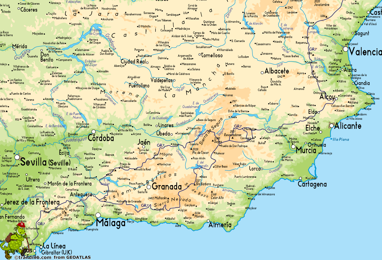
The logic behind "Stage 1" is that it takes you to the point where the GR7 splits into a northern and southern option.  As it happens the split takes place at Villanueva del Cauche but to make my itinerary work for me I went slightly beyond that point.

The month leading up to starting the walk, by the way, was terrible. I was committed to the walk but had massive reservations. Wasn't sleeping and had an almost overwhelming feeling that I was about to fall flat on my face and make a complete fool of myself. Getting to Spain and starting the walk was just a wonderful release, the doubts disappeared and for the first few weeks I was powered by euphoria.

Tarifa is the perfect place to start the walk, it feels like and is  the edge of Europe. It is also very windy (apparently the wind is virtually non-stop) and the views across narrow Straits of Gibraltar to the Africa are sharp and clear. Would have been nice to have stopped for the night in Tarifa but instead I trudged along the beach and shortened what would otherwise have been a 41.5 next day walk to Los Barrios. I stayed at the Hotel Artevida which was fine but expensive compared to most of my accommodation in Spain.

Cork Oak Grove
The first full day's walking through the Los Alcornocales Natural Park with its cork oak forests was nice rather than amazing.  Lots of wind turbines along the route as well as a large reservoir but the views back to Tarifa and across the narrow straights to Africa were wonderful.  Horrible and painful walk along a road to finish the day in Los Barrios.  Stayed at the Hotel Real in which was cheap, simple and good fun.

The 34 kilometre walk to Castillo de Castellar is a poor one - long walk past a huge rubbish dump, a walk down a quite road, and then a walk along a cycle path alongside a busy road before you finally get off road just before the finish. A shame because Castillo de Castellar, a wonderful hill top town, is a great place to finish the day. Stayed in an absolutely amazing hotel, part of the castle itself.

After two big days the third day was a short 15 kilometres walk to Jimena de la Frontera, through pleasant if not particularly exciting countryside. You spend quite a bit of time walking alongside a famous (apparently) wide gauge railway line. I really liked Jimena de la Frontera and you can see why a lot of ex-UK residents have decided to live there. I managed to stay in another really lovely hotel, the Casa Henrietta, brightly decorated with real Andalucian style.

After Jimena de la Frontera the countryside really starts to match the towns for interest. After an initial climb up to about 800 metres your into fairly open moorland with great views all the way back to Gibraltar. It's a tough 40 kilometre walk and you stay high all the way until the final descent into Ubrique, another recently interesting and ancient town rammed up against huge cliffs. Didn't stay in a hotel in Ubrique, was the guest of the local tourist board, but there are hotels in the town or nearby. The Hotel Ocurris is one which seems to attract recommendations.

On the next day I walked all the way to Ronda but this is fabulous countryside and anyone sensible would have stopped along the way. Stopping options with accommodation include Villaluenga del Rosario (bit close to Ubrique) or Montejaque (bit close to Ronda). Either way this is a wonderful stretch. Highlights included the march up the Roman road (everything still there) to Benacoaz; the walk through the valley to the pretty village of Villaluenga del Rosario (nestling under the Navazo Alto) or the walk through the limestone scenery of Sierra de Grazalema Natural Park. If you do decide to walk all the way to Ronda, like I did, you'll find the walk after Montejaque painfully long.

The Stunning Sierra de Grazelema
I only stayed one night at Ronda, which is probably a capital offence for people who love Spain. It is a lovely town, an important tourist destination and has lots of places to stay.

The next day's walk was another poor one, difficult to find the route between Ronda and Arriate and a lot of road walking between Arriate and Cuevas del Becerro.  Cuevas del Becerro is slightly away from the route but there is no accommodation at Serrato which would otherwise have been a good place to stop.  Had a nice afternoon in Cuevas del Becerro, there was a fiesta, but not much of a draw otherwise.

The following walk to El Chorro is much nicer although a bit tougher than I had anticipated.  Lovely open arable countryside with long views.  Ardales, half way along, is another interesting looking town (the walk takes you over a Roman bridge) with accommodation if you want to really short day.  The second half of the walk is a lot tougher, a nice ridge walk and then a climb up to the spectacular reservoir above El Chorro and a really steep climb down.  I stayed in a camp site with huts but there is other accommodation available.
El Chorro
The walk to Antequera via the small town of Valle de Abdalajis is a pleasant one but with a nasty bit of road walking in the middle.  Valle de Abdalajis has accommodation and if you wanted to break the walk up with a day off than there is enough to see in Antequera famous for its ancient bronze age tombs.  Lots of accommodation but I stayed in the Hotel Colon which was OK.

The last day of this stage was a really wet one for me which was a shame because it meant I missed the views of the El Torcal peak in the natural park to the south of the route which has the same name.  Not a bad walk but you do have to work you way underneath the motorway and there is a bit of associated road walking before you eventually get to Villanueva del Rosario.  Stayed in the Hotel Venta Las Delicias which was cheap, cheerful and good fun.

Most people would sensibly walk section of the GR7 at a slower pace and there are enough accommodation options to do things differently to the way I did it.  Perhaps the key issue is whether or not to stay at Ronda.  If you have been there before than it would make sense to stay at Montejaque, then Arriate, then Ardales, Valle de Adbalajis and then Antequera.  Another day to the itinerary but perhaps more sensible.

If your interested in what it felt like at the time please have a look at the daily diary entries.

Tarifa to Los Barrios
Los Barrios to Castillo de Castellar
Castillo de Castellar to Jimena de la Frontera
Jimena de la Frontera to Ubrique
Ubrique to Ronda
Ronda to Cuevas del Becerro
Cuevas del Becerro to El Chorro
El Chorro to Antequera
Antequera to Villanueva del Rosario


Back to Spain, back to Andalucia

Still working out which bits of the E4 I liked the best but certainly loved walking in Spain and Andalucia in particular. When I walked there in March I had to choose between the southern and northern variants of the GR7 and I have no idea whether my decision to walk along the northern route was the right one. Any excuse to go back to Spain I’m going with Christine in October to walk the southern variant and find out how it compares with what I have done already.

We haven’t got enough time to do the whole variant so we’re going to start at Ventas de Zafarraya and walk through to La Calahorra, about 230 kilometres. First days walking will be on the 15th of October and we will be walking for 9 days. I think you need at least 15 days to do the whole route.

For second half of the walk we are going to be joined by Juan Holdago. Met Juan last year on my second day out of Tarifa. This was an amazing stroke of luck as well as an amazing coincidence. Turns out that Juan is an expert on the GR7 and all things walking in Spain. He has his own web site (www.jaholgado.com) and helped Michele Lowe and Kirstie Shirra write their guide “Walking the GR7 in Andalucia”.

Although I was lucky enough to meet Juan face to face there is now a group of people providing each other with advice about the E4 something which will hopefully continue to develop. I got great help from Sue and Ivan Godrey who have already walked along the GR7 variant, David and Carole who have been walking the E4 for several years and provided advice on accomodation, and Menno Wolters who helped early with the route.

Hope to blog every day and the schedule is as follows:

15th October - from Ventas de Zarraya to Alhama de Granada
16th - to Jayena
17th - to Albunuelas
18th - to Lanjaron
19th - to Buibon
20th - to Travelez
21st - to Berchules
22nd - to Bayarcal
23rd - to La Calahorra


Finding which is the best variant in Andaculia is one several questions about the E4 route which I intend to enjoy answering over the next 18 months or so. I also want to walk all the way along the GR7 from El Boixar to Pyrennees and see if this as a better option than the official route which takes you down to the coast; whether you could somehow incorporate the Robert Louis Stephenson Trail into the walk in the Massif Central; and, whether there is a higher level option in the Vercors.

Finding answers to these questions is just an excuse to go back to some amazing walking country but at the same time, and because I enjoy it, I do intend to keep working on the blog and, hopefully with collaborators, develop it as a source of information for anyone interested in the E4. In particular I’d like to revisit the work on the stages I did when planning the walk and update it to take account of what I found when I actually did it. This will include a more comprehensive look at the accommodation options.

While I’ve managed to raise nearly £6,000 for my charity in Nepal (and thanks to everyone who sponsored me) it's still a long way from my target (£20,000!) but I don’t intend to give up. I think I may have squeezed as much out of family and friends as I can so I’m now starting to look at other options (please let me know if you have any suggestions). Currently looking at ways the web-site could generate income and, for example, will use any revenue from adverts on the web-site as a contribution to the target.