The Nordapline Wietwanderweg 01 (NW 01 for short) is the toughest part of the E4 route. It's an important planning consideration, for the whole project, to know, both, whether I'm capable of walking it, and have enough time to complete it before it snows. So, with my wife Christine, we planned an 8 day test which started on the shore of Lake Constance on the 9th of July.
The first thing to say is that we may have been very lucky with the weather. My experience of walking in the Alps is that the weather is more reliable than the UK, but for the test run it was near perfect. Also spring arrived late this year and the flowers came both late and at once - this meant that we saw "everything" from meadows full of orchids, gentians and globeflowers, and all colours, with all shades of purple, blue and yellow.
The second thing to say is that all the planned stops were "pre-programmed" (booked) and the programming had been based on the projected time needed to walk from one hutte to the next. The timings were provided by the hutte web sites (and used on all the signs in Austria). We were carrying our stuff but travelling light.
Stayed in Bregenz on the Friday night before the walk having arrived after a flight to Zurich and a series of train journeys. The Swiss train service is brilliant, and our ticket included an itinerary with both the changes and the platforms involved. Bregenz is a nice place with an amazing open air opera where staging takes place in, yes in, Lake Constance. We spent the afternoon lake swimming - almost like a normal holiday.
My first mistake was to plan the end of Day 1 and not the start. By and large, I don't think you need to book the huttes, particularly in early July, but we were desperate get our own rooms to avoid dormitories. I had booked the Freschenhaus, just to south of the Hoher Freschen, but had not worked where to start in order to get there at a sensible time. We guessed at this in a taxi out of Bregenz, so not a lot science, and chose a point on the NW 01 east of Dornbirn and west of Bodele. The route looked about 18 kms long and involved a climb of about 1400 metres. The first clue as to the likely duration came at the Lustenaur Hutte (11-30) which said 6.5 hours to Hoher Freschen. We had already been walking for 2 hours so this meant a long first day but not a disaster. Trouble was we had no real idea about a "standard walking hour" - could you stop to rest and how fast do you have to go to keep up.
The slightly worrying thing is that the next hours revealed my ability to ignore the all evidence. Despite a map, and despite knowing where I was, I still thought that the peak in the reasonably located middle distance was the Hoher Freschen ignoring the evidence said it was further away.
 |
| How far? |
At about 5 we climbed my version of the Hoher Freschen which was, in fact, the Morzelspitze. Nice mountain, great views, but not the Hoher Freschen. Worst still is that we didn't even need to go up it but, at the top, the grim reality of where had to get to - the real Hoher Freschen - was clearly visible, looked huge and a long way away. At 6 we got to Altenhofaple and got some water from two students milking cows by hand and seriously considered staying there. The signs were telling us another 2 hours to Hoher Freschen. After running on empty, however, we started to revive and at 7.30 were at the foot of right mountain and at its top just after 8.
 |
| Stepping carefully up to Hoher Freschen |
On the way up, very near the top, we discovered what the ladder symbol on the map means. It doesn't mean a ladder - it's more an official symbol for scary - fixed ropes, narrows ledges, big drops and scary - and at the end of a long 10 hour walking day.
After that, 15 minutes or so to the hutte, nice dinner, a host dressed like Roy Orbison but not such a good singer (did an interesting over the top German version of an REM song), cold water wash and bed.
Day 2
Not a brilliant nights sleep and woke up unable to find my camera. Went through all the pockets in my back-pack, checked with Roy Orbison, even walked back up to the top of Hoher Freschen, but no luck. Set of to Damuls fed up but determined not to let incompetence ruin the trip. The route was brilliant, three hours where the path sticks limpet like to the contour refusing to give or take a metre of climb or fall. Great scenery but no pictures. Eventually climbed over a small arrete and then dropped down to the Partaaple Hutte, ordered a banana milkshake, and with a small cloud appearing on the horizon dived into the rucksack for my waterproofs. Found my camera. An incompetent incompetent.
The rest of the route down into Damuls was not so nice, down amongst the trees again and very hot. Christine started to wilt and we stopped at a farmhouse offering snacks. No one there but the woman in charge. Christine ordered a cheese sandwich and I asked for ham. What we got was two platters with wonderfully arranged home grown produce. By the time we left the place was packed.
Arrived in Damuls to discover the place I had booked was out of town and a mile of the route. Christine goes on strike but after a stand-off in the sun (sitting on opposite sides of road incommunicado) she rings the hotel, tells them her husband is an idiot and can't read a map and would they mind if we cancelled. They didn't and we book into a nice hotel in the middle of town where the waitresses wore Austrian national costumes. Lovely room, a bath - good result Christine.
Day 3
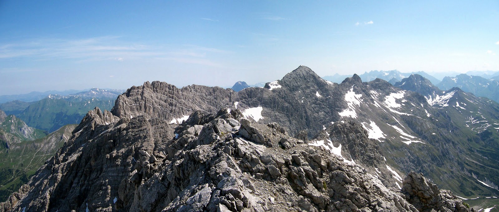
Fueled up from good food (watched the world cup final and an enormous thunder storm) we set of at about 8-30 for Biberache Hutte. Everything fresh and clear after the rain and after a 40 minute walk to Faschina (where we should have stayed) we start the walk proper. After a steady 300 metre climb in the shade of the Zafernhorne we cross a col at Furka (1900 metres). Suddenly, in bright sunshine,we get a brand new vista. Immediately in front of us is an amphitheatre with a path outlined on the middle terrace. In the distance, forming the horizon, is the jagged profile of the Zitterklapfen, which we know we have to cross.
 |
| Zitterklapfen on the horizon |
Having completed the terrace walk, crossed a small ridge, we walk through a sea of yellow flowers - could have been Globeflowers or Mountain Avons - down to an ancient farmhouse where we meet our first walker of the day, a woman in her seventies with an enormous stick. She points out the path up to the Hechschere Pass.
 |
| Marching across a meadow below Hechschere |
 |
| Clinging on at the top of Hochshere |
To be honest I'm not sure what it means to be an experienced alpine walker (the qualification for the NW 01) but the last fifteen minutes to the top of the Hechschere Pass, and the first fifteen coming down were the scariest 30 minutes walking I have done. Lots of steel ropes, lots of narrow paths, and lots of loose scree all hanging above bone crushing, deadly drops. The views from the top were great, another new vista, including the even higher mountains we would be crossing in the next few days. However the fear associated with the climb, and the anticipation of the descent, meant that we didn't savour either the view (or our second helping of bread and liver sausage) as much as we should have done. We did, of course, get down but neither of us would relish doing it again.
The rest of the walk was pretty tough, high up on the side of the valley underneath the Zitteklapfen. Just as you started to relax, the route would take you across a landslip and the path became treachourous again. Our nerves were further stretched by some aggressive cows, less submissive than their UK sisters, who were keen to chase us off their mountain. Stopped to chat with a couple of walkers who asked us which way we had come and their sharp intake of breadth when we said the Hochshere Pass made us feel a lot better.
 |
| Look no path |
 |
| Biberache Hutte |
Arrived at the Biberache Hutte at about 6, 10 hours since leaving Damuls. It was lovely, great landlady, great food, great beer, our own room and a shower (cold). Made friends with a German baker and his teenage son who were doing a new circular route, the Lechquellon Runde, which coincided with our route for the next three days. He gave me a potted history of Alpine Clubs and how local associations sponsor particular huttes. Because of the web site I used to plan the route, we were staying in huttes sponsored by local associations from the German Alpine Society - need to do some more work on this as membership makes accommodation really cheap.
Day 4
Theoretically Goppinger Hutte, the Day 4 target, was only 4 hours from Biberache Hutte - a "rest day" after 10 hours on Day 3. What was becoming apparent, however, was that keeping pace with the Austrian standard hour walking pace was tough, particularly when you were going up hill. Day 4 involves 880 metres of climb, 480 descent over 12 kms all to be completed in 4 hours.
All the descent was in the first couple of hours, downhill into woods and where tree roots crossed the paths making the going treacherous. At the bottom and across a stream you suddenly had to pull yourself up a twenty foot near vertical face using a steel rope - a sudden change of pace.
 |
| Rope assisted climb |
 |
| Climbing up to Goppinger |
After climbing up the Hochschere the day before we had really got our hill climbing act together. Christine set the pace and we climb really quickly. After 600 metres we stop for lunch (we bought a "luncheon bucket" picnic from Biberache - enough food for two days) and the views are great. The last 200 metres climb are through a classic kast landscape with its limestone blocks and crossing lots of patches of snow. Arrive at the hutte at about 3, it's packed with a large party of Germans, and despite booking a room we have to share. It was with the German baker and his son who arrive an hour or so after us so not so bad.
The main topic of conversation over dinner was the extent of my navigation/planning skills. Christine's confidence, stretched by the huge walks on Day 1 and Day 3, was given a further knock when we worked out that I had screwed up for Day 5. Because I'm a penny pincher, and didn't buy the map needed for a tiny part of the route, my proposed Day 5 schedule was wrong. The direct route to Ravensburger (4 hours) meant going down the valley and along the road and was not the NW 01 or the E4. The real route meant going to Frieburger Hutte (4 hours 30) and then to Ravensburger (another 4.30) - 9 hours excluding breaks and given the track record this could be much longer. Christine, with German back-up, was now questioning the latter parts of the route as well.
Day 5
 |
| I think these are Chamois |
 |
| Holding on |
Out of the hutte by 7.30, lovely day, felt great to be walking at that time, and the target was Ravensburger via Frieburger. After 20 minutes we get our reward for such an early start and saw deer, could be chamois, grazing on the scree. The first part of the walk, the Steinmayerweg, was a huge contour route, along high often narrow paths, perched beneath the 2500 metre peaks in the Johanneskopf. Great walk but amber on the scary scale if Hochschere was red. Last hour before Freiburger the path was very broken and progress slow but we made the hutte by 12 (220 metres climb, 500 descent) and rewarded ourselves with huge plates of pasta.
The walk in afternoon was one of the best I have ever done. An initial climb, a long grassy contour was followed by some really tough kast walking. Stretched out across the limestone blocks was a party of elderly Germans who were really struggling necessitating a helicopter rescue for one of them. Then the really big climb up to the Aufstieg zum Gehrengrat (2439 metres) - a big climb but through a alpine grassland all the way. After resting at the top, where the alpine grassland ended abruptly with a cliff, the route took us along the ridge and then sharply down into the valley below empty apart from numerous marmots with their distinctive whistle.
 |
| Top walk |
Despite not getting to the Hutte until about 6.45 we both felt great. Immediate beer, followed by food, hot shower and in bed by 8.30. Brilliant day.
Day 6
 |
| Christine with friend |
Paid for Day 5 a bit on Day 6. The weather had turned misty and the walk was less inviting. The target was Stuttgarter Hutte, about 12 kms to the east involving 1100 metres of climb and 720 metres of descent. Mist all the way and after 2 hours we encountered serious skiing country. A skier myself it's horrible see the damage done to the landscape when the snow has gone. The only point on the whole trip when the signs failed to work was at the ski station above Zurs where, after struggling to find the path, we tried to get on the chair lift down the mountain but the maintenance crew, although sympathetic, said no.
Of course cheats never prosper, and if we had got the lift, we would have missed Anthony Gormley's statues which at the moment are staring across the valley halfway down to Zurs. Zurs itself, once we got there, was awful, an empty ski resort, a ghost town, where, in the summer, you can't even get a coffee.
 |
| Sunset at Stuttgarter Hutte |
Climbing out of Zurs we had to endure a tarmac road for about an hour (of course I know realise that the route I took although the NW 01 was not the E4 which was on a variant - the variant I think, which didn't go to Stuttgarter, may have been better). Anyway after a stop at the Trittalpe Hutte and goats milk the weather and the scenery got better. The final 300 metre climb up to Stuttgarter Hutte was tough at the end of the day, but it's a great location and after dinner (wurst and saur kraut) we were treated to a lovely sun-set.
Day 7
Christine's confidence in my navigation had returned only marginally. We were booked into the Kaiserjochhaus which was theoretically 8 hours away but we had a debate about whether it was too far. As a fail safe we also booked the Leukircher Hutte which is half way. We set of at 7.40 in great form, another brilliant morning. Climbed over the pass (2420 metres) underneath Wilder Kasten and then down to Erlachealpe (1922 metres) and then up again over a pass at about 2,300 metres. Some amber path walking high up on the valley coming up from Erlacheaple but after that in the sun in a stunningly beautiful green valley. Arrived triumphantly at the Leuckircher Hutte at 11.15 and talked to the landlord about a potential world record. Celebrated with an enormous plate of potatoes and grilled spam - a delicacy in these parts. We were now back on the E4 proper (signed for the first time) and the Alderweg which is clearly a major Austrian long-distance route with a much higher profile than the NW 01. Looks like there has been a lot of investment in this part of the route - new signs, new steel ropes.
 |
| Grilled spam and eggs - yes! |
 |
| The E4 really exists |
Final stretch of the walk was a lovely contour walk high above the St Anton valley and nailing the schedule we arrived at Kaiserjochhaus at 3.30. No single rooms available and the prospect of spending the last night in the mountains in a dormitory is too much. I am also wearing a T-shirt for the second day and need to keep moving to stay ahead of my own smell. We decide to drop down to Pettneu. Found a lovely hotel (hotels are really cheap in the summer) and got cleaned up.
 |
| No dormitories please |
Next day bus and train to Zurich meaning that instead of walking we have a city break.
All in all a great holiday, brilliant walk, really helpful test run. Separate blog on the lessons learnt.
Special thanks to Christine, not known for her patience, she never expressed more than gentle doubts for what were justifiable concerns about the quality of the plan.


